Drone Control - Ground Control Station (GCS)
How do you control a drone?
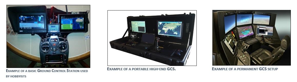
The ground control station is the nervous system of the operation. The GCS will control the launch, flight, and recovery of the UAV. It also processes the data from the internal and external sensors of the payload. To perform this task the GCS incorporates the following subsystems:
- UAV status readouts and controls
- Payload data displays and controls
- Map for mission planning, monitoring location and current flight path of UAV
- Ground terminal of the data link system
Ground Control stations come in various complexities and sizes. These platforms can range from backpack sized to permanent buildings.
Can a drone fly itself?
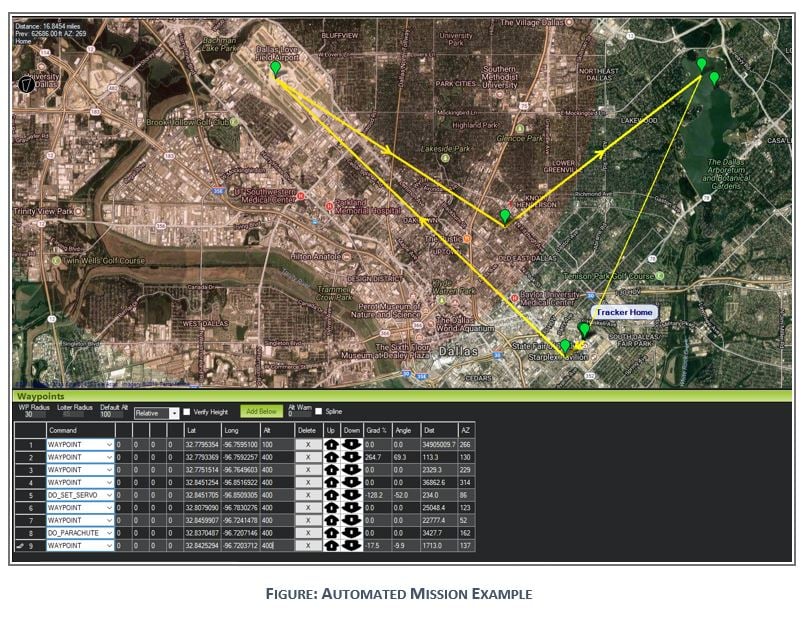
To illustrate the power of an automated system an example mission is plotted using the mission planner software. For this example, the starting location of the Cotton Bowl Field in Dallas, TX is selected. The target location is the DFW International Airport.
Since the concern of landing in tight places is a reality during this mission, a quadcopter capable of the range required for this mission is selected. For this example, the quadcopter will be capable of a maximum speed of 25 mph and a maximum endurance of 1 hour. These goals are easily met using today’s technology.
Using the mission planning software, it is first required to set the “home” location of the quadrotor. This will give the quadcopter a “failsafe” and return location if anything were to go wrong with the aircraft. Once the home location is set, the user can plot the waypoints using the google maps interface. These waypoints can contain altitude information and commands for hardware on the UAV itself.
This mission starts out at 100 ft; however, the UAV quickly climbs to 400 ft before making its path to DFW Airport. Once waypoint #4 overtop of the DFW Airport has been reached, waypoint #5 is activated. Using “DO_SET_SERVO” releases a mechanism on the quadcopter, delivering a package on top of DFW Airport. Once this is complete, the UAV can retreat to its home location, or any other location specified on the flight map.


.png?width=2030&height=497&name=Background%20(1).png) Airsight is a leading sUAV security software company that specializes in delivering sUAV Airspace Detection Solutions for Critical Infrastructures, Universities, Spectator Sports, Prisons, Events, and more. Our UAV security experts integrate projects of all scopes and sizes nationwide, through a
Airsight is a leading sUAV security software company that specializes in delivering sUAV Airspace Detection Solutions for Critical Infrastructures, Universities, Spectator Sports, Prisons, Events, and more. Our UAV security experts integrate projects of all scopes and sizes nationwide, through a